River
Park Plan
for
Tung Chung New Town Extension (West)
(EP
No. EP-519/2016)
September
2022
1.
Project Description
The development of Tung Chung New
Town Extension (TCNTE), comprising Tung Chung East (TCE) and Tung Chung West
(TCW), is a mega-scale and complex project aiming to provide land to meet the
future housing economic and social development needs of Hong Kong. Due to the
fact that the proposed works are geographically separated, the implementation
of mega-scale Project is divided into two packages, namely TCE and TCW
respectively. In accordance with the tight delivery programme, the Project will
be implemented in phases under separate contracts for the developments of TCE
and TCW.
2. Scope
of Works for Tung Chung New Town Extension
The Tung Chung New Town Extension
project (the Project) comprises the following elements:
(i)
reclamation of the seabed by a
non-dredged method at TCE to form a total of about 130 hectares of land;
(ii)
construction of about 4.9 kilometers
of seawalls, with an eco-shoreline, three drainage box culvert outfalls, three
circulation drains and a seawater intake at TCE;
(iii)
provision of infrastructure for Tung
Chung Area 58, including construction of a single two-lane road with a footpath
and the associated utility works;
(iv)
site formation works at TCW;
(v)
construction of the River Park
including a visitor centre at TCW;
(vi)
construction of proposed open space;
(vii)
construction of sustainable urban
drainage systems at TCW;
(viii)
construction of roads, footpaths,
cycle tracks and the associated junction / road improvement works;
(ix)
engineering infrastructure works
covering drainage, sewerage, waterworks (including a fresh water service
reservoir, a salt water service reservoir and a salt water pumping station),
common utility tunnels and landscaping works; and
(x)
implementation of environmental
mitigation measures and environmental monitoring and audit programme for the
works.
3. Implementation
Programme
The Contract No NL/2020/05 – Tung
Chung New Town Extension – Site Formation and Infrastructure Works at Ma Wan
Chung (i.e. Contract 5) at TCW has been awarded in May 2021 and is scheduled
for completion in 2025. The main contractor for Contract No. NL/2020/05 is
Build King – Richwell Civil Joint Venture (BKRCJV).
The Contract No NL/2020/06 – Tung
Chung New Town Extension – Site Formation and Infrastructure Works at Tung
Chung Valley, Phase 1 (i.e. Contract 6) at TCW has been awarded in May 2021 and
is scheduled for completion in 2025. The main contractor for Contract No.
NL/2020/06 is China Railway Group Limited (CREC).
The detailed design for the first
phase of site formation and infrastructure works at TCE and TCW (First Phase
development) has been completed, while the detailed design for the remaining
phase of site formation and infrastructures works is in progress.
4. Submission
under EP
The River Park will be implemented
via two phases: Phase 1 which is to be implemented by Contract 6, and Phase 2
which will be implemented at later stages by subsequent works contract. This
submission is prepared based on the latest information of Contract 6 according
to the relevant requirements contained in the EM&A Manual, EIA Report and
EP.
This River Park Plan will be further
updated and submitted to EPD for approval before the commencement of works for
River Park Phase 2.
1.3 Environmental
Permit Requirements
1.4 Purpose
of the River Park Plan
1.5 Scope of
the River Park Plan
2.2 River
Revitalization Section
2.3 Design Details
of River Park (Phase 1 "River Revitalization Section")
2.4 River
Park (Phase 2 "Habitat Preservation Section")
3
Planting Design of River Park
4
Stormwater Attenuation and Treatment Ponds
6
Maintenance, Management and Monitoring
6.1 Maintenance
and Management Responsibility
6.4 Control
of Invasive Flora and Fauna Species
Appendix A
Implementation Schedules of River Park (Phase 1) and Stormwater
Attenuation and Treatment Ponds
Appendix B
Maintenance Schedule for River Park Phase 1 in Operation Stage
1.1.1 China Railway Group Limited (known
as CREC) was commissioned by the Civil Engineering and Development Department
(CEDD) of the Government of Hong Kong Special Administrative Region (HKSAR) in
May 2021 as the contractor to provide construction works for the site formation
and infrastructure works at Tung Chung Valley, Phase 1 (Contract No.:
NL/2020/06).
1.2.1
In
mid-1996, the Government completed the Territorial Development Strategy Review
(TDSR) which identified housing shortfall in the medium to long term.
The TDSR also identified the North Lantau New Town (NLNT) as a strategic
growth area, among other areas to meet the territorial housing demand, with a
revised population target of 320,000 by 2011.
1.2.2 In 2004, the Administration
formulated a concept plan for planning initiatives on Lantau (Concept
Plan). The Concept Plan was then revised in mid-2007 taking into account
comments collected from the public consultation (Revised Concept
Plan). Under the Revised Concept Plan, Tung Chung is to remain a
comprehensively planned new town for a population of 220,000 with adequate
community facilities and regional facilities to serve the whole of
Lantau.
1.2.3
The CEDD and the
Planning Department (PlanD) jointly commissioned Agreement No. CE
32/2011(CE) - Planning and Engineering Study on the Remaining Development in
Tung Chung (P&E Study) in 2012. The P&E Study aims at identifying
development potentials and opportunities to extend Tung Chung into a distinct
community to meet housing, social, economic, environmental and local
needs. Under the P&E Study, various planning, engineering and
environmental studies were carried out to formulate a development scheme to
extend existing Tung Chung to Tung Chung East (TCE) and Tung Chung West (TCW).
1.2.4
The P&E Study
adopted a three-stage Public Engagement (PE) programme to facilitate public
discussions and foster consensus building. Taking into account the public
views and the planning and technical assessments, the Recommended Outline
Development Plans (RODPs) for TCE and TCW were finalized under the P&E
Study and were endorsed in January 2015. The planned new population of
TCE and TCW under the RODPs would be around 120,000 and 25,000
respectively. With the new population in TCE and TCW, the total planned
population in Tung Chung will reach about 270,000 upon full development.
1.2.5
The
development theme of Tung Chung New Town Extension (TCNTE) will pursue a
sustainable and balanced approach while taking account of its strategic
location and the synergy effect to make Tung Chung a regional commercial hub
for retail and office developments.
1.2.6
The
scope of works for Contract No. NL/2020/06 includes site formation and
engineering infrastructure works for the development of TCW at Tung Chung
Valley. The scope of the contract comprises the following principal works
components:
(a) Construction of Road L29 and L30;
(b) Road Improvement of Chung Mun Road
and Shek Mun Kap Road;
(c) Site formation works for Areas 42
and 46 for public housing development;
(d) Construction of Common Utility
Tunnel (CUT);
(e) Sustainable Urban Drainage System
(SUDS) and provision of roadside bioswales, stormwater attenuation &
treatment ponds;
(f)
Construction of River
Park and river revitalization works;
(g) Environmental impact mitigation
measures including woodland compensation; and
(h) Ancillary works including
associated civil, geotechnical, structural, electrical and mechanical
engineering and landscaping works.
1.3
Environmental
Permit Requirements
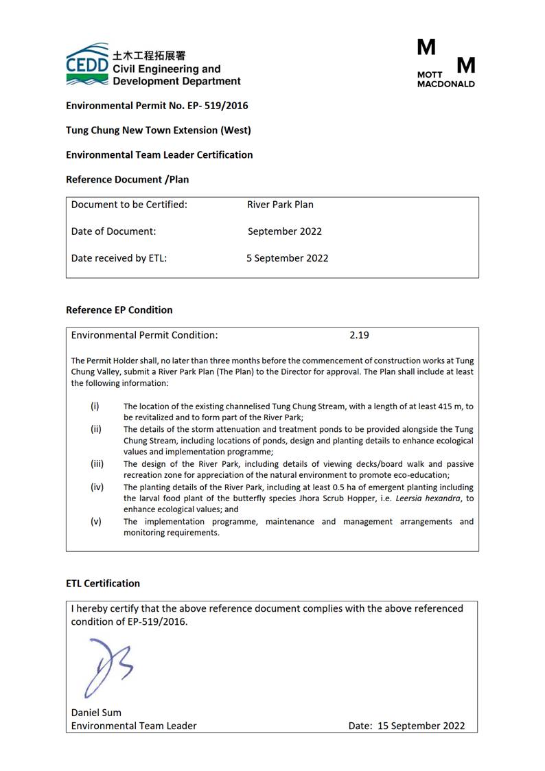
1.3.1
According to Clause 2.19 of the Environmental Permit No.
EP-519/2016, "The Permit Holder shall, no later than 3 months before the
commencement of construction works at Tung Chung Valley, submit 3 hard copies
and 1 electronic copy of the River Park Plan (The Plan) to the Director of
Environmental Protection for approval. The Plan shall include at least
the following information:
·
the
location of the existing channelised Tung Chung Stream, with a length of at
least 415m, to be revitalized and to form part of the River Park (Section 2.2
of this Plan)
·
the
details of the Stormwater Attenuation and Treatment Ponds to be provided
alongside the Tung Chung Stream, including locations of ponds, design and
planting details to enhance ecological values and implementation programme
(Section 4 of this Plan)
·
the
design of the River Park, including details of viewing decks / boardwalk and
passive recreation zone for appreciation of the natural environment to promote
eco-education (Section 2.3 and 2.4 of this Plan);
·
the
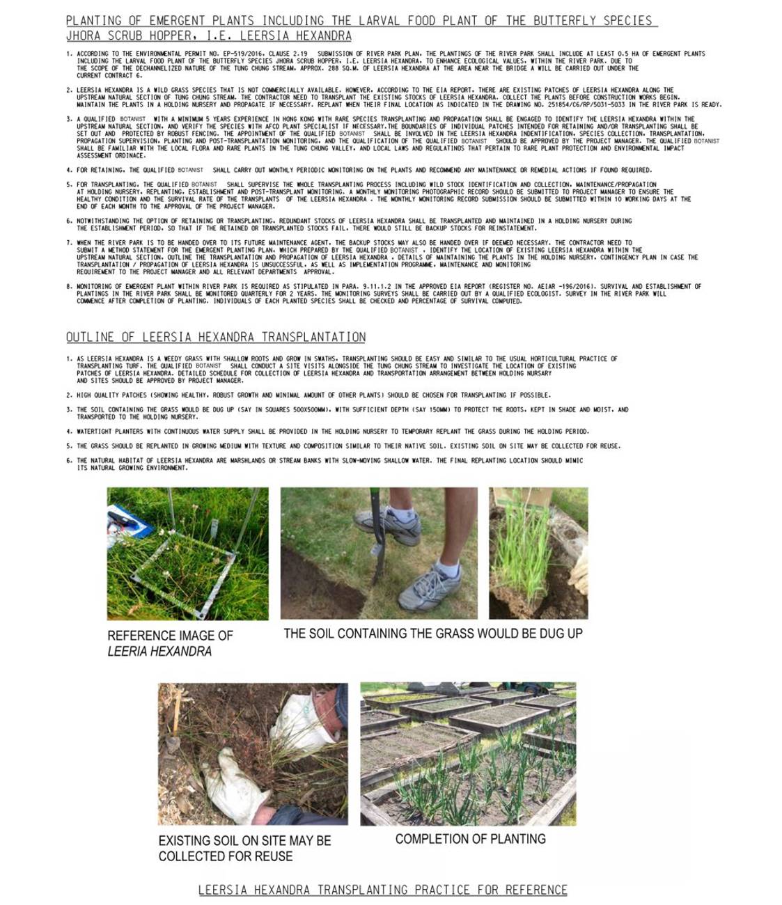
planting details of the River Park, including at least 0.5 ha of emergent
planting including the larval food plant of the butterfly species Jhora Scrub
Hopper (Aeromachus jhora), i.e. Leersia hexandra, to
enhance ecological values (Section 3 of this Plan); and
·
the
implementation programme, maintenance and management arrangements and
monitoring requirements. (Section 5 and 6 of this Plan)
1.4
Purpose of the River Park Plan
1.4.1 This
submission (The River Park Plan) is to fulfil the requirements under Clause
2.19 of the Environmental Permit No. EP-519/2016.
1.5
Scope of the River Park Plan
1.5.1
The scope of this
submission is on Phase 1 of River Park comprising the implementation of River
Park (Phase 1) (River Revitalization Section) and Stormwater Attenuation and
Treatment Ponds (SATPs) A01, A02, A04, A05 and A07. This submission will be
updated in future to include Phase 2 of River Park which comprises the
implementation of River Park (Phase 2) (Habitat Preservation Section) and SATPs
A03 and A06.
2.1.1
Tung Chung
Stream is one of the few relatively large rivers in Hong Kong that still
preserves its natural setting from its headwater to the estuary. The
lower course of the River comprises two main tributaries: the Eastern Shek Mun
Kap Stream and the Western Mok Ka Stream.
2.1.2
Approximately
625m in length and about 15m in width of Tung Chung Stream in the northeast of
Shek Lau Po is channelized during the development of Tung Chung New Town in the
1990’s. The ecological value of this engineered section is limited as it
has been channelized. This engineered section has also undermined the
ecological connection between the upstream natural section of Tung Chung Stream
and the estuary further downstream. In order to restore the ecological
connection between the upstream and downstream of Tung Chung Stream, existing
channelized section of Tung Chung Stream upstream of Chung Mun Road to the
northeast of Shek Lau Po will be revitalized. On the other hand, the section
of Tung Chung Stream to the immediate upstream up to Shek Mun Kap
(approximately 360m long) is still in its natural status and should be
preserved. River Park will be implemented at the channelized section of
Tung Chung Stream and the section upstream till Shek Mun Kap Road.
2.1.3
The
River Park would occupy an area of approximately 3.3 ha along a total length of
775m. It will be located at Tung Chung Stream covering a large portion of
the channelized section (415m in length) together with the immediate upstream
natural section alongside Fong Yuen area up to Shek Mun Kap Road (360m in
length).
2.1.4
The River
Park will be implemented in two phases with Phase 1 to be implemented under
this contract (NL/2020/06). Phase 2 will be implemented at later stages
under subsequent works contract.
·
River
Park Phase 1 (River Revitalization Section) – The section of the channelized
section of Tung Chung Stream upstream of Chung Mun Road to the northeast of
Shek Lau Po (about 415m).
·
River
Park Phase 2 (Habitat Preservation Section) – The immediate upstream natural
section of the channelized section of Tung Chung Stream alongside Fong Yuen
area up to Shek Mun Kap Road which is under design stage currently and the
commencement of construction is targeted to be in 2024 (about 360m).
2.1.5 The
habitat preservation section will be implemented in River Park Phase 2.
An updated River Park Plan providing necessary information about River Park
Phase 2 will be submitted to relevant authorities before the commencement of
works for River Park Phase 2.
2.1.6
Diagram
1 shows the
location and proposed extent of the River Park Phases 1 and 2. River Park
Phase 1 will be constructed under Contract No. NL/2020/06 (i.e.
Contract 6). Phase 2 will be implemented at later stage by subsequent
works contract.
2.1.7 The design theme of River Park is
Preservation First + Ecological Enhancement "ECO TRAIL". It aims to provide a
connection between wildlife habitats and human being. Visitors are
connected to the wildlife within Tung Chung Valley by walking on the boardwalk
and viewing deck going along the River Park as shown in Diagram
2. In addition, the Park will allow varieties of both
water-friendly culture and activities to take place to enhance the diversity
and dynamic of the journey. The River Park will promote eco-education by
setting up viewing decks / boardwalk, passive recreation zone for appreciation
of natural environment. It will also help to prevent massive
infrastructures within the park areas to avoid impacts due to construction and
human disturbance. Though there will be visitors during the
operation phase, the River Park will be for the restoration of the stream and
also enhancing the ecology, and thus the design will be conservation-orientated
with the visitor access limited to certain areas. It is not expected that
there will be disturbance from the operation of the River Park on Tung Chung
Stream.
2.2
River Revitalization Section
2.2.1
The channelized
section of Tung Chung Stream is located to the northeast of Shek Lau Po.
Revitalization includes removing the hard edges of the channel and utilizing
large, smooth river pebbles to stabilise the embankments, and to allow feature
aquatic planting to approach close to the water's edge allowing visitors a
tactile relationship with the water.
2.2.2
The
total length of channelized section of Tung Chung Stream is approx. 625m,
in which approx. 415m is within River Park Phase 1, shown in Diagram 1.
2.2.3
For
the existing channelized section of the River, it would be reconstructed by
using natural materials of a channel without obstacles for movement of aquatic
fauna and providing suitable habitats, while still maintaining sufficient
drainage capacity.
2.2.4
Some of the existing disturbed areas of the Tung Chung
Stream within the proposed River Park will form interactive activities zones to
promote the water-friendly culture.
2.2.5
The River Park design aims at creating a sense of
place for the River Park. The design intention is to keep the area as
natural appearance as possible and ecologically functioned.
2.2.6
For the disturbed / urbanized
riverside areas of low ecological value (the western bank of the natural
section, and both sides of the channelized section), amenity enhancement can be
achieved by landscape planting and preservation of existing trees, which would
facilitate recreational function of the River Park at the same time.
Trees unavoidably to be removed will be compensated in appropriate locations to
mitigate the landscape impacts.
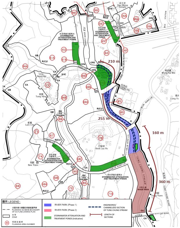
Diagram
1 – Layout Plan for River Park
2.3
Design
Details of River Park (Phase 1 "River Revitalization Section")
2.3.1 Under
the River Park Phase 1 "River Revitalization Section", it enhances the
river bed to provide ecological linkage with downstream habitat, enrich the
vegetation on the existing channelized section and then upgrade the landscape
value of the existing disturbed area.
2.3.2 Table
2.1 describes the
elements of Phase 1 "River Revitalization Section".
2.3.3
There will be passive
recreation zone in both Phase 1 "River Revitalization Section" and Phase 2
"Habitat Preservation Section". Passive recreation activities include
boardwalks, riverside walk, resting station, viewing platform, arboretum, etc.
The indicative proposed layout and elements of River
Park (both Phase 1 and Phase 2) are provided in Diagram
2.
2.3.4
The
detailed design of River Park is subject to change and coordination with the
operation/ maintenance authorities and stakeholders.
Table 2.1 – Elements in the River
Revitalization Section
|
River
Revitalization Section |
Description |
|
Elevated boardwalk
along riverside (Riverside Walk) |
A boardwalk is
proposed to be built along the western bank of the River Park opposite to the
Visitor Centre as a walking path forming the riverside walk. The intention of
including a boardwalk is to integrate educational resources into a leisure
walking experience for community benefit, which is configured along the
revitalized river section. In addition,
these boardwalks provide an adventure role when walking through the
meandering path. Typical section and elevation of boardwalk are shown
in Diagram 3 and Diagram 4 respectively. |
|
Feature
Landscape Stream Crossing (Active Water Play) |
River Park
crossing will be located adjacent to the Visitor Centre. Stepping stone
will be formed on the stream bed, as shown in Diagram 2.
Since such river crossing method will affect the river bed, it is preferred
to be considered at the existing channelized section. This river
crossing, which function as a water friendly element to get people closer to
the nature, is provided adjacent to the Visitor Centre to provide synergy for
the promotion of water-friendly culture. |
|
River Park
Visitor Centre (Visitor Centre) |
River Park
Visitor Centre will be located at the southern part of River Park Phase 1, as
shown in Diagram 2 and Diagram
5. The design
concept of the Visitor Centre is Flow of Experience for "Start from
Nature, End with Nature". It would be a physical journey and
experience that starts from understanding the Nature, and ends with knowledge
and physical experience of the Nature through various forms of Audio-Visual
interactive activities. |
|
Stormwater
Attenuation and Treatment Pond (Attenuation Pond Education) |
The pond (SATP
A04) will be next to the proposed River Park Visitor Centre. Associated
facilities such as educational signages would be provided at this SATP for
educational purposes. |
|
Ecological
Measures |
Some ecological
measures like Eco Bag, Aquatic Plants and Planting on Gabion will be located
along the river bank and river bed of River Park to enhance connectivity and
biodiversity, shown in Diagram 6. |
|
Some specially
made granite rocks will be used for the fish ladder. The fish ladders
enable fish to pass around the barriers by swimming and leaping up a series
of relatively low steps into the waters on the other side, as shown in Diagram 2 and 2.1. |
|
|
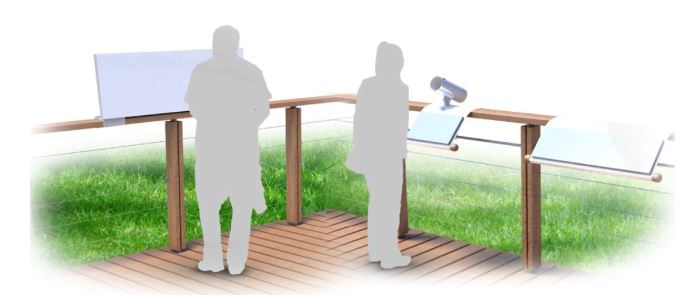
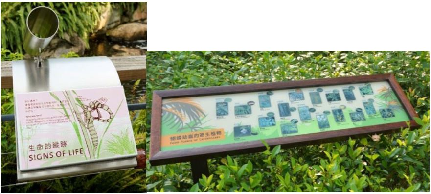
Education
Signage and Information Signage |
Education
signage as a feature to promote eco-education in accordance with EP-519/2016
– Clauses 2.19 (iii) will be provided to inform the public about the
development of River Park. Its perspectives are shown in Diagram 7a and Diagram 7b.
Appropriate information signage will also be provided to warn the public
about potential hazards within the Park and ensure visitors following general
rules of the Park. The education signage and information signage will
be set up along the boardwalk and visitor walkway. |
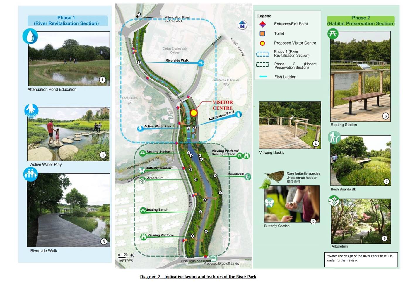
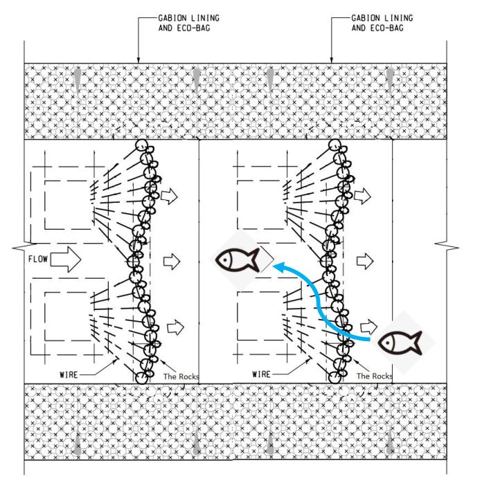
Diagram 2.1 – Indicative
Design of Fish Ladder
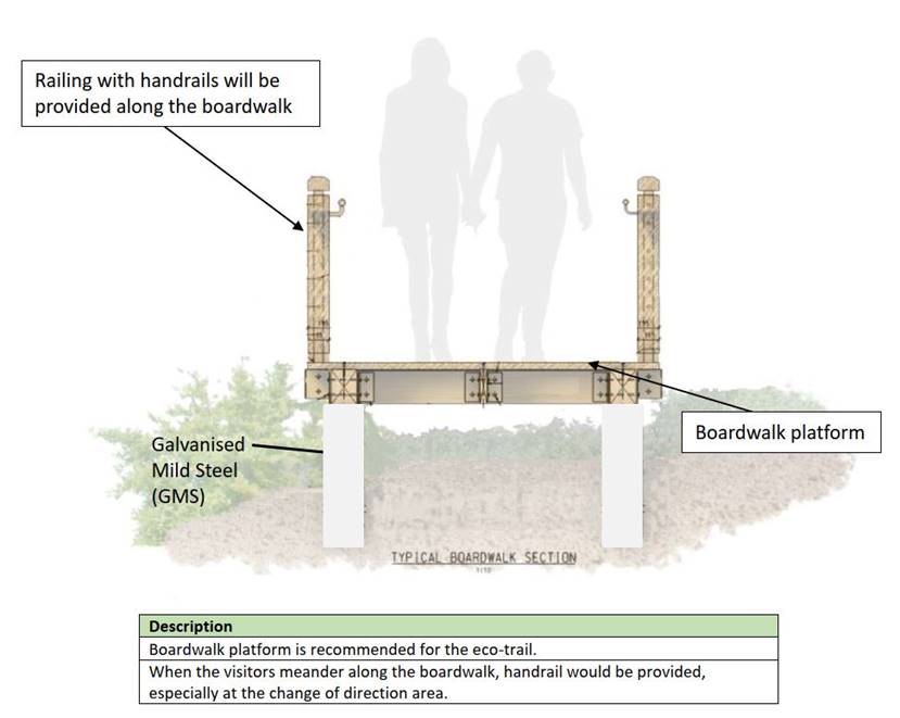
Diagram 3 – Typical Section of
Boardwalk Platform
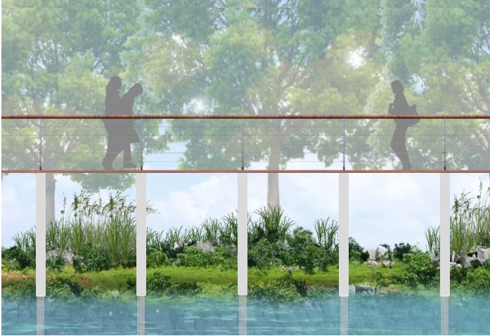
Diagram 4 – Elevation of Boardwalk
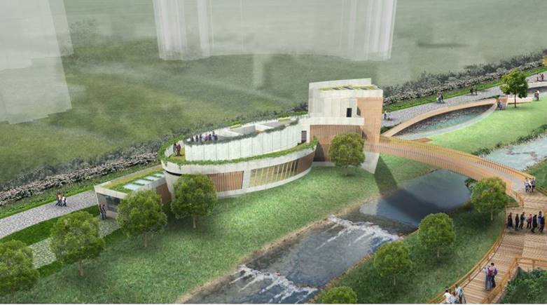
Diagram 5 – Indicative
Design of the Visitor Centre
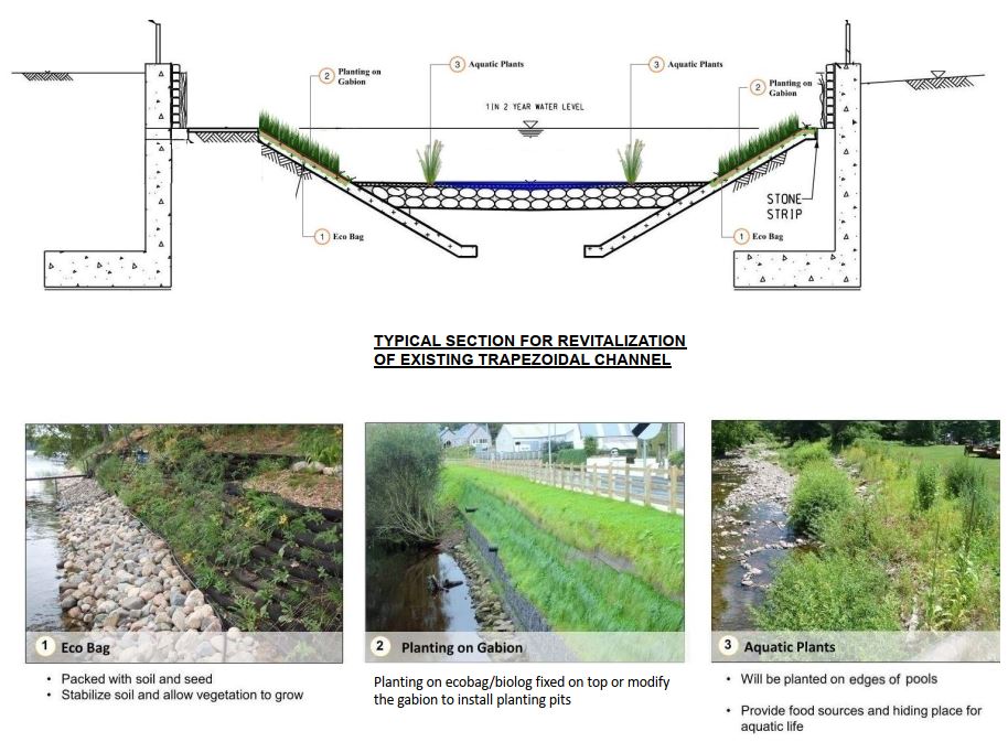
Diagram
6 – River Park Ecological Measures for Connectivity and Biodiversity
Enhancement
Diagram
7a – Education Signage Perspective
Diagram
7b – Reference Image of Education Signage
2.4
River Park (Phase 2 "Habitat Preservation
Section")
2.4.1
The habitat
preservation section is to respect the existing natural environment to promote
eco-education. It will minimize alternations / changes of the vegetation
in particular the riparian vegetation to preserve existing habitats and the
larval food plant for the rare butterfly species Jhora Scrub Hopper (Aeromachus
jhora). In addition, it will accommodate the passive facilities like
viewing platform and boardwalk to engage visitors’ maximum appreciation of the
natural environment.
2.4.2
As
mentioned in paragraph 2.1.4 that the habitat preservation section will be
implemented as River Park Phase 2, which will be implemented in later stage
under subsequent works contract, this Section will be updated in future
submission.
3
Planting Design of River Park
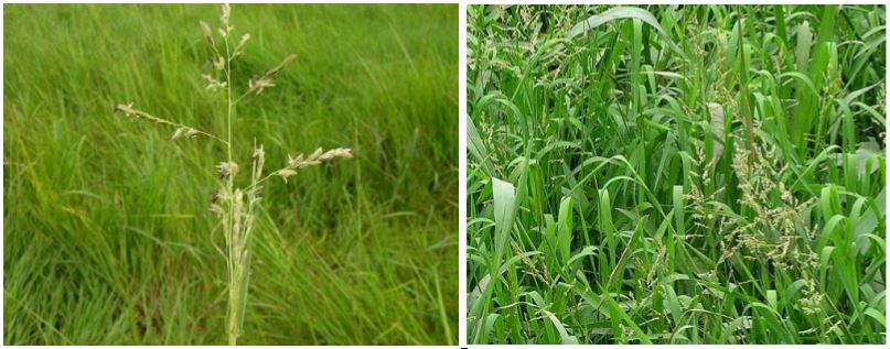
3.1.1
Suitable nectar plants
as well as butterfly larval food plants such as Leersia hexandra (李氏禾) will be one of the key theme
planting in the River Park. The photos of Leersia hexandra are
shown in Diagram 8. While Leersia hexandra
is the larval food plant of the rare butterfly species Jhora Scrub Hopper (Aeromachus
jhora), provision of suitable nectar plants could effectively attract adult
butterflies of various species to areas designed as butterfly garden and along
walking trail.
3.1.2
As per the requirement
of EP-519/2016 (Clause 2.19(iv)), at least 0.5ha of emergent planting including
Leersia hexandra shall be included to enhance the ecological values of
the River Park. Under River Park Phase 1, approximately 0.667 ha
of emergent planting (within which 288 sq. meters of Leersia hexandra)
will be planted along the riverside and in Stormwater Attenuation and Treatment
Ponds as shown in the highlighted area in Diagram 9. SATP
A01, A02, A04, A05 and A07 includes the emergent planting under Phase 1 of
River Park. The emergent planting for River Park Phase 2 will be
reviewed by subsequent works contract. Please refer to Table 3.2
for the proposed size of emergent planting in River Park (Phase 1). For Leersia
hexandra, which is a wild species not commercially available in the market,
the transplanting of healthy stock of Leersia hexandra to temporary
nursery will be carried out and propagated by the Contractor. As existing
patches of Leersia hexandra varies in size in the wild, a reasonable
turf size following GS Clause 3.27 is anticipated through successful transplant
and propagation by the Contractor. Please refer to Diagram
10 for more details regarding the translocation proposal for Leersia
hexandra.
3.1.3
Shrubs, herbs and
native trees will be planted throughout Phase 1 of the River Park. The
proposed plants species are selected with consideration of the accessibility
for planting, future maintenance, and the ecological linkage with other
existing habitats. The examples list of recommended species to be planted
throughout Phase 1 of the River Park, in which comments from the relevant
department and interest groups are incorporated, are shown in Table 3.1
and the examples of the emergent plant species proposed for planting in Phase 1
of the River Park are shown in Table 3.2. The Landscape Designer of the
River Park should make reference to the recommended plant list when designing
the landscape and the contractor will make early arrangement for the
availability and sufficient quantity of suitable plant species. Leersia
hexandra will be included in the emergent planting together with other
recommended plant species in the River Park as required under the requirement
of EP.
Diagram
8 – Photos of Leersia hexandra to be planted throughout Phase 1 of
River Park
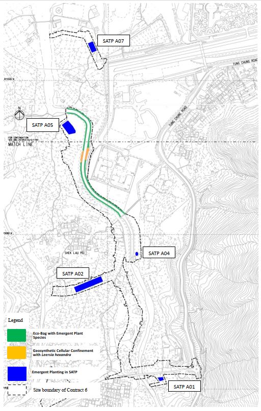
Diagram 9 – Location of Emergent
Planting in River Park Phase 1
Table 3.1 – Examples
list of recommended species to be planted throughout Phase 1 of the River Park
|
Scientific Name |
Chinese Name |
|
Melastoma sanguineum |
毛菍 |
|
Nephrolepis auriculata |
腎蕨 |
|
Rhaphiolepis indica |
石斑木 |
|
Rhodomyrtus tomentosa |
桃金娘 |
|
Ficus pumila |
薜荔 |
|
Sterculia lanceolata |
假蘋婆 |
|
Viburnum odoratissimum |
珊瑚樹 |
|
Morella rubra |
楊梅 |
|
Syzygium hancei |
韓氏蒲桃 |
|
Sapium sebiferum |
烏桕 |
|
Ilex rotunda var. microcarpa |
小果鐵冬青 |
|
Pyrus calleryana |
豆梨 |
|
Garcinia oblongifolia |
嶺南山竹子 |
|
Pongamia pinnata |
水黃皮 |
Table
3.2 – Examples of the emergent plant species proposed
for planting in Phase 1 of the River Park
|
Scientific Name |
Chinese Name |
Respective Sizes (Height x Spread, mm) |
|
Juncus effusus |
燈心草 |
Herbaceous plants (200 x 200) |
|
Alternanthera sessilis |
蝦鉗菜 |
Herbaceous plants (200 x 200) |
|
Crinum asiaticum var. sinicum |
文殊蘭 |
Herbaceous plants (500 x 500) |
|
Cyperus malaccensis var. brevifolius |
短葉茳芏 |
Herbaceous plants (200 x 200) |
|
Equisetum debile |
筆管草 |
Herbaceous plants (500 x 500) |
|
Hedychium coronarium |
薑花 |
Herbaceous plants (500 x 500) |
|
Leersia hexandra* |
李氏禾* |
Turf.** |
* Note: Under Clause 2.19 (iv) of EP (EP No. EP-519/2016),
at least 0.5 ha of emergent planting including the larval food plant of the
butterfly species Jhora Scrub Hopper, i.e. Leersia hexandra, to enhance
ecological values will be planted in River Park.
** Note: For Leersia hexandra, the Contractor shall follow
contract requirement to transplant existing plants from the site and propagate
the plants in a nursery for replanting in the River Park. Stocks for
planting shall comply with turf as per General Specification for Civil
Engineering Works (2020) Clause 3.27.
Diagram
10 – Details of Translocation Proposal for Leersia hexandra
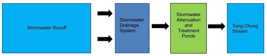
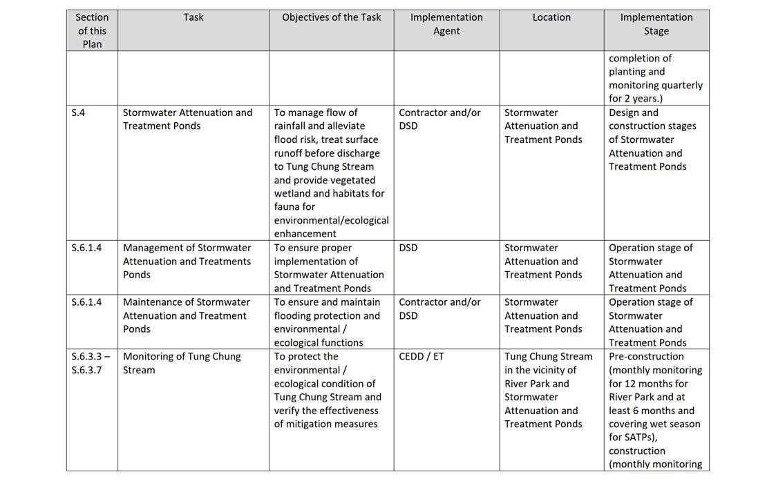
4.1.1
The Sustainable Urban
Drainage System (SUDS) will be put in place in the Tung Chung Valley, which
includes porous pavements, bioswales, as well as stormwater attenuation and
treatment ponds. When it rains, surface runoff in the area will be
collected through the drainage system, purified and treated naturally before
conveying into the Tung Chung Stream. In this way, water resources and
water quality will be controlled more effectively. Besides, the
stormwater attenuation and treatment ponds will be built in areas of lower ecological
value as far as possible and green features will be added so as to reduce the
impact on the surrounding natural habitats.
4.1.2
Design Concept
Stormwater
Attenuation and Treatment Pond systems aims to provide water quality treatment
and flood alleviation. Each pond system will serve as a regional
stormwater management system, treating runoff from roadways, future and
existing developments and as a bonus, serve as freshwater habitats. The
stormwater management strategy of the Stormwater Attenuation and Treatment Pond
is described by Diagram 11. Indicative
locations of the Stormwater Attenuation and Treatment Pond system are shown in Diagram 12.
4.1.3
Ecological Function
The
stormwater attenuation and treatment ponds provide habitat for attracting
aquatic invertebrates and other wildlife.
4.1.4
Design Features
Each
set of Stormwater Attenuation and Treatment Ponds systems consist of three
sections with the following primary features:
1)
Sedimentation Pond
Ø
Receives
the runoff from the road drainage system;
Ø
Reduces
flow velocities; and
Ø
Allows
deposition of sediment and entrained pollutants.
2)
Treatment Pond
(Biofiltration Zone)
Ø
Allows
treatment action to occur while runoff travels slowly through dense wetland
vegetation to remove fine particulates and encourage nutrient uptake.
Ø
Aquatic plant species commonly found in wetlands in
Hong Kong are proposed to be planted. Diagram 14
gives some examples of these plant species. The contractor will make
early arrangements for suitable plant species' availability and sufficient
quantity.
3)
Attenuation Pond
Ø
Receives
treated runoff from the treatment pond (Biofiltration Zone) for discharge into
the Tung Chung Stream.
Examples
of these features of proposed stormwater attenuation and treatment pond are
shown in Diagram 13 and 13.1.
Diagram
11 – Philosophy for the Proposed Stormwater Attenuation
& Treatment Ponds
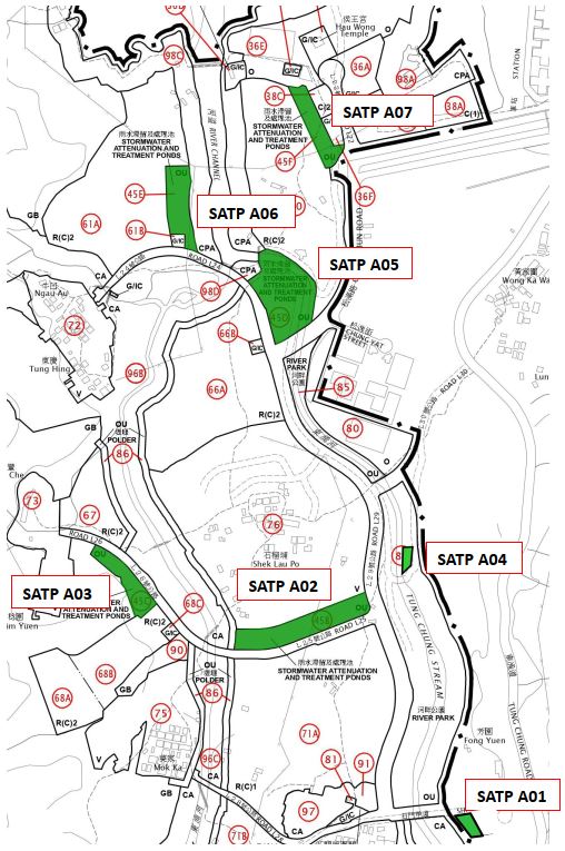
Diagram 12 – Location plan of
Stormwater Attenuation and Treatment Ponds
Note 1: SATPs A01, A02, A04, A05 and A07 will be implemented under Phase 1 of
River Park (Contract 6) and SATPs A03 and A06 will be implemented under Phase 2
of River Park (Subsequent works contract)
Note 2: Layout of SATP A04 is adjusted due to site
constraints for other facilities within the River Park including Visitor
Centre, emergency vehicular access, sump pump, etc.
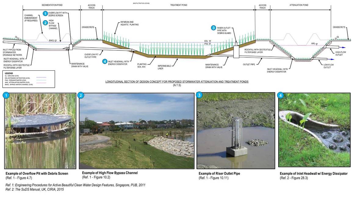
Diagram 13 – Design Concepts and
Features of Stormwater Attenuation & Treatment Pond
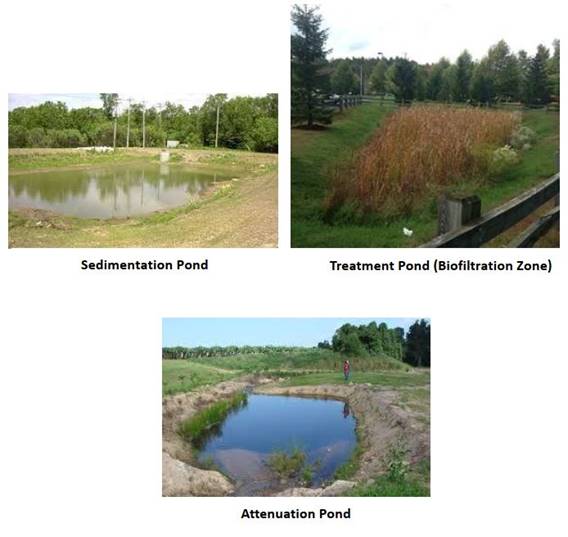
Diagram 13.1 – Examples of the
three major zones/ pond (i.e. Sedimentation Pond, Treatment Pond (Biofiltration
Zone) and Attenuation Pond)
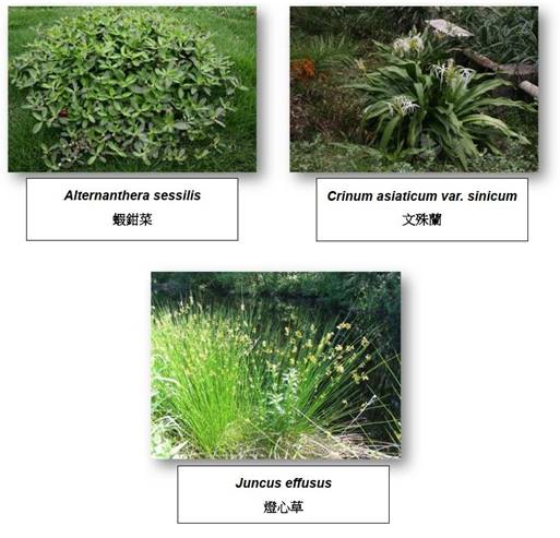
Diagram
14 – Examples of Plant Species in Treatment Pond (Biofiltration Zone) of
Stormwater Attenuation & Treatment Ponds
5.1.1
As
mentioned before, the River Park will be implemented in 2 phases. Phase 1
of River Park is included in this Contract NL/2020/06 while Phase 2 of River
Park will be implemented in a separate subsequent work contract.
5.1.2
The
programme for implementing Phase 1 and Phase 2 River Park are summarized in the
following table:
Table 4 - Programme for
implementing Phase 1 and Phase 2 River Park
|
River Park |
Tentative Time of Commencement |
Tentative Time of Completion |
|
Phase 1
Works |
2022 |
2025 |
|
Phase 2
Works |
2024 |
2028 |
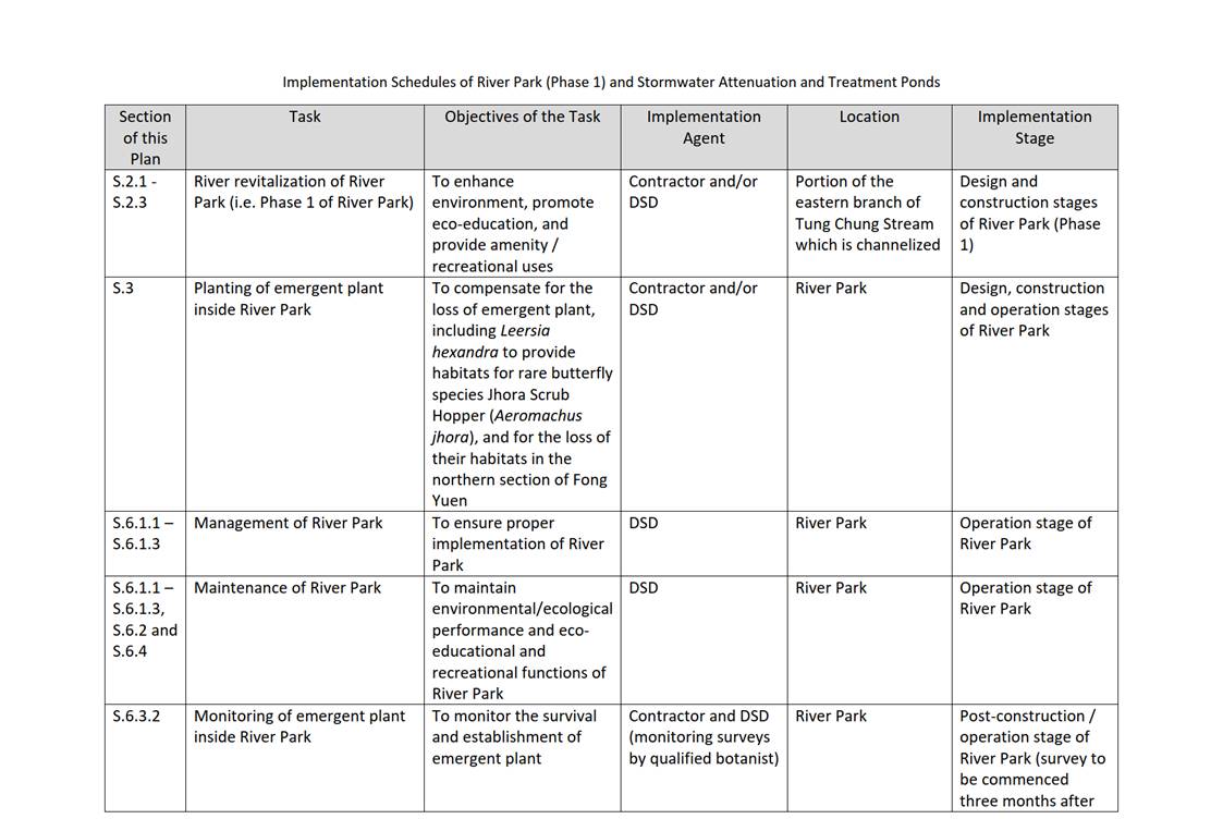
5.1.3
The
implementation schedules of the River Park (Phase 1) and Stormwater Attenuation
and Treatment Ponds are given in Appendix A.
5.1.4
The construction programme for the
Stormwater Attenuation and Treatment Ponds are summarized in the following
table:
Table 5 – Construction Programme
for the Stormwater Attenuation and Treatment Ponds under Contract NL/2020/06
|
SATP |
Tentative Time of
Commencement |
Tentative Time of Completion |
|
A01 |
2023 |
Early 2025 |
|
A02 |
2022 |
Early 2025
|
|
A04 |
2023 |
Early 2025 |
|
A05 |
2023 |
Early 2025 |
|
A07 |
2022 |
Early 2025 |
6.1
Maintenance and Management Responsibility
6.1.1
The
maintenance and management responsibility of the proposed River Park are taken
into account of the future management and maintenance of the works, as per DEVB
TCW No. 6/2015 "Maintenance of Vegetation and Hard Landscape
Features".
6.1.2
Under
the current provision, it is agreed that Drainage Services Department (DSD)
will be the maintenance and management agent for the routine operations of
River Park.
6.1.3
In this regard, DSD will be the maintenance and
management department for all the proposed works within the River Park and the
River Park Visitor Centre. The River Park will be handed over to DSD as
soon as the respective phase mentioned in Section 5 is completed.
6.1.4
DSD will be the
maintenance and management department for Stormwater Attenuation and Treatment
Ponds. The Stormwater Attenuation and Treatment Ponds of A01, A02, A04,
A05, A07 are under River Park Phase 1, while A03 and A06 are under River Park
Phase 2 (see Diagram 12). The maintenance and management works
includes inlets, outlets, drains, sump pumps and irrigation points.
6.2.1
Maintenance is
required for the River Park to ensure that revitalization, habitat conservation
and eco-educational performance of Tung Chung Stream could be sustained.
Common problems are encountered in some of the watercourses in Hong Kong
include aggradation / erosion, overgrowth of vegetation, and weed / exotic
species invasion. Suitable maintenance measures tailored for and specific
to Tung Chung Stream, taking into account the ecological design and function of
the river, are needed and shall be provided to avoid compromising other
functions (e.g. hydraulic). In order to ensure the
hydraulic function of Tung Chung Stream, desilting works shall also be carried
out by DSD annually or whenever it is considered necessary. Please refer
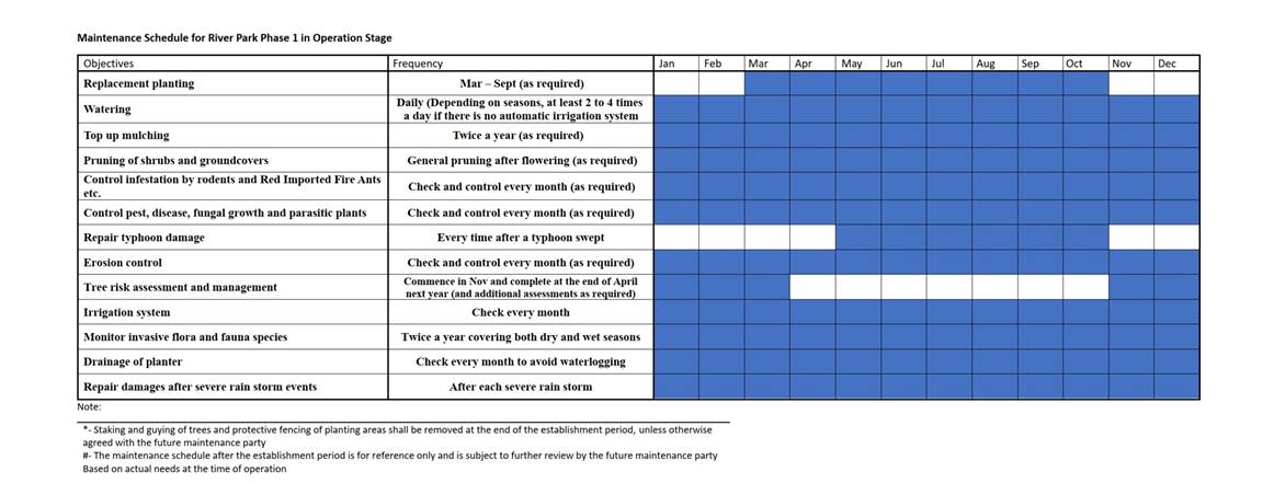
to Appendix B on the maintenance schedule for River
Park (Phase 1).
6.3.1
Apart from the
maintenance and management works mentioned above, in order to ensure habitat
preservation of the River Park and ecological condition of Tung Chung Stream,
long-term monitoring of emergent plant inside River Park Phase 1 and also Tung
Chung Stream are required (see Table 6.1).
Monitoring of Emergent Plant inside
the River Park
6.3.2 Planting
of emergent plant species including the larval food plant of the rare butterfly
species Jhora Scrub Hopper (Aeromachus jhora), i.e. Leersia
hexandra, should be provided in the future River Park. Survival and
establishment of planted emergent plants in the future River Park will be
monitored quarterly for 2 years. The monitoring surveys shall be carried
out by a qualified botanist and ecologist. Survey in the future River
Park will commence three months after completion of planting. Selected
individuals of each planted species will be checked and percentage survival
computed. Supplementary planting will be recommended when
necessary. Wildlife use of the planted vegetation will be monitored.
Monitoring
of Tung Chung Stream
6.3.3
For protection of Tung Chung Stream
and verifying the effectiveness of mitigation measures, monitoring on Tung
Chung Stream is recommended for public works in or near Tung Chung Stream,
including construction of River Park (together with revitalization of
channelized section of Tung Chung Stream) and stormwater attenuation and
treatment ponds, etc. The monitoring should include pre-construction baseline
survey, construction phase monitoring and post-construction monitoring. The
monitoring items should cover the environment of the stream courses, the water
quality, and the stream fauna. During the works period of the river park,
monitoring shall be undertaken to identify and evaluate any impacts with
appropriate actions taken as required to address and minimise any adverse
impact found.
6.3.4
As the proposed River
Park will have construction works inside Tung Chung Stream for revitalizing the
channelized section, pre-construction (baseline) monitoring shall be carried
out on a monthly basis for a 12-month duration. The duration of baseline
monitoring for Stormwater Attenuation and Treatment Ponds shall not be less
than 6 months and covering wet season. The construction phase monitoring
shall cover the full construction programme on a monthly basis. The
post-construction monitoring shall cover a 12-month duration after the
completion on a monthly basis.
6.3.5
Water quality monitoring,
including in situ measurements and collection of water samples for laboratory
analysis, shall be conducted at each monitoring location. Dissolved
Oxygen (in % saturation and mg/L), pH value, temperature, turbidity and
salinity shall be measured in situ while the other parameters, including
Biochemical Oxygen Demand (BOD5), Chemical Oxygen Demand (COD), oil and grease,
suspended solids (SS), Total Kjeldahl Nitrogen (TKN), Total Phosphorus (TP),
E. coli and Ammonia (NH3) shall be analysis at a HOKLAS
accredited laboratory.
6.3.6
The water quality index (WQI) of Tung Chung Stream
shall also be assessed during post-construction monitoring in order to monitor
the overall state of the Stream. The calculation of WQI could be
referenced to the latest version of River Water Quality in Hong Kong.
6.3.7
Action and limit levels, which
should take into account the species and season, for construction phase will be
established with reference to baseline survey data. The responses when
triggering these limits are outlined in Table 6.2. Monitoring of stream fauna
includes fish and aquatic invertebrate. Methodology should follow standard
methods of direct observation and active search. The frequency should be
monthly.
Table 6.1 -
Monitoring for Emergent Plant inside the River Park Phase 1 and for Tung Chung
Stream
|
Phase |
Methodology |
|
Monitoring
of Emergent Plant inside the River Park Phase 1 |
|
|
Post-construction (Survey to be commenced three
months after completion of planting and monitoring quarterly for 2 years) |
Quarterly monitoring surveys for survival and
establishment of plantings (including emergent plant) in the River Park.
Selected individuals of each planted species will be checked and percentage
survival computed. |
|
Monitoring
of Tung Chung Stream |
|
|
Pre-construction (Baseline) (12-month duration for
River Park and at least 6 months and covering wet season for Stormwater
Attenuation and Treatment Ponds) |
Monthly quantitative replicate surveys of the
environment of the stream courses, the water quality, and the stream fauna
using standardized methodology at the fixed points, the number of which
should be determined prior to the first monitoring event. |
|
Construction (monthly basis which cover the full
construction programme) |
Monthly quantitative replicate surveys of the
environment of the stream courses, the water quality, and the stream fauna
using standardized methodology at the fixed points determined in the
pre-construction phase. |
|
Post-construction (cover a 12-month duration after
the completion) |
Monthly quantitative replicate surveys of the
environment of the stream courses, the water quality, and the stream fauna
using standardized methodology at the fixed points determined in the
pre-construction phase. |
Table 6.2 – Action and Limit Levels and Responses to
Evidence of Declines in Aquatic Fauna
|
Action Level |
Response |
Limit Level |
Response |
|
Construction Phase |
|||
|
Non-compliance of Action Level to be
established after baseline monitoring, (such as reduction in taxa diversity
or abundance), such that response is triggered. |
Investigate cause and if cause
identified as related to Project instigate remedial action to remove or
reduce source of disturbance |
Non-compliance of Limit Level to be
established after baseline monitoring, (such as reduction in taxa diversity
as well as abundance), such that Limit Level response is triggered. |
Investigate cause and if cause identified
as related to Project instigate further
remedial action. |
6.4
Control of Invasive Flora and Fauna
Species
|
Once a year |
|
|
How to
remove exotic and invasive species |
For invasive flora: Remove the invasive plant by hand
picking before its flowering season. For invasive fauna: Capture and remove by handpicking
and traps. |
|
Target
invasive species |
Invasive flora: Mikania micrantha, Typha
angustifolia, Ipomoea cairica, Sonneratia apetala, Cuscuta chinensis,
Leucaena leucocephala, Pueraria, Cassytha, Mimosa pudica, Sesbania cannabina. Invasive fauna: Trachemys scripta elegans,
Oreochromis niloticus, Pomacea canaliculata. |
Implementation
Schedules of River Park (Phase 1) and Stormwater Attenuation and Treatment
Ponds
Maintenance
Schedule for River Park Phase 1 in Operation Stage